Showing posts with label raster. Show all posts

Friday, 21 December 2018

Combine Raster Bands

To combine multiple single-band rasters into a single multi-band raster, use the RasterBandCombiner transformer.
For example, combine the DTM and DSM height rasters into a single 2-band raster. Or combine the pluvial, fluvial and combined depth rasters into a single 3-band raster.

See also https://blog.safe.com/2018/08/bring-2d-data-cesiumjs/


Friday, 8 June 2018

Overlapping raster with vector data

When overlaying rasters with lines or polygons, don't convert the raster to vector format, but instead convert the line or polygon dataset to raster.

First use a 3DForcer transformer and set the 'elevation' of your lines or polygons to 1. Then use the NumericRasterizer transformer, setting 0 as the Background Value. This will create a binary raster where the lines or polygons have a raster value of 1, and everything else 0.

Then point this rasterized vector dataset and the original raster both to the RasterExpressionEvaluator transformer, and do Preserve; A[0]*[B0]. This will effectively give an intersection raster.


Tuesday, 27 February 2018

Raster Checking

Before processing a raster, check the raster. After loading the raster in the Data Inspector, select the Information button and drag a box to show the raster details.

Clicking in the raster, shows the raster cell details of the clicked cell.

Raster Bands

If the raster is a colour raster, i.e. an image, it should have 3 bands displaying the RGB values;
If the raster is a numerical raster, e.g. a DTM, it should have 1 band displaying the numerical value.

To remove any unwanted bands (e.g. alpha band), use the RasterSelector transformer followed by the RasterBandKeeper or RasterBandRemover transformer.


To separate the RGB bands, use the RasterBandSeparator transformer.

Raster NoData

NoData by default means no colour = transparent.

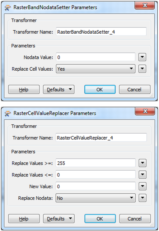
To set the raster's NoData value on a numerical raster, first define the NoData value using the RasterBandNodataSetter, followed by a RasterCellValueReplacer setting all values outside the valid domain to the newly selected NoData value.

Raster Display

To display a raster, use the RasterInterpretationCoercer transformer.

Combine Raster Bands

To combine multiple single-band rasters into a single multi-band raster, use the RasterBandCombiner transformer. For example, combine the ...